How We Plan Our Overland Trips

So by now you know that we are in the midst of preparing to embark on an pic adventure. An adventure that will have us moving into an RV full time and exploring all that North America has to offer, both on-road in our RV and off-road in Black Betty our Jeep Adventure vehicle.
We have already planned our overall route across the country covering the next year through late 2023. First heading down the east coast into Florida before heading across the southern edge of the country chasing winter before heading up the west coast from California to Washington State, before going up through Canada and into Alaska.
Just recently though we decided to make a change. Rather than going from Arizona, into California and up from there, we decided to cut back and up through Utah, into Colorado and Wyoming and Montana before heading West out to Washington State and Olympic National Park. The heart of the country holds some of the places that are some of the highest up on our bucket lists, Zion, Bryce Canyon, Yellowstone, and Glacier National Parks just to name a few. Wyoming and Montana in general are places that we have always wanted to explore.
We don’t just plan our general route, we even identify the specific RV park, campground, or camp spots that we plan to stay at. We love spontaneity and would much rather play it by ear, but recent conditions make this really hard to do in a full size RV. We are not the only ones with the idea to buy and RV and get out and explore. Campgrounds are selling out months in advance and it is almost impossible to stumble in last minute and find availability. You need to reserve your spots months ahead of time in order to be safe. We have already secured our reservations all the way down the east coast and out of Florida already taking us from August through the end of the year.
I have spent a ton of time researching and planning. It is a lot of work but there are some tools that we have found that make the process easier. So how do we actually plan our trip? The first thing you need to do is determine where you want to go and plan your overall route. We have a list of the places we want to visit from years of dreaming. While Yellowstone might be high on our list though, we are not just heading straight for Wyoming. We want to relax, travel and enjoy ourselves, and visit the places we want to see when we are in the area. Our bucket list doesn’t dictate the overall route, but does indicate the overall direction we head in.
The other main driver of our route is weather and time of year. In general; we want to stay away from winter and the cold whenever possible. Once the general route is established we really start to get into the details. We take it state by state and do a lot of research and create a list of all the things we want to do and see there. We Google best things to do in say Virginia, and then more specifically for say Shenandoah National Park. I then go into Google My Maps and put a pin in each place we want to visit and save them to our places we want to visit list.
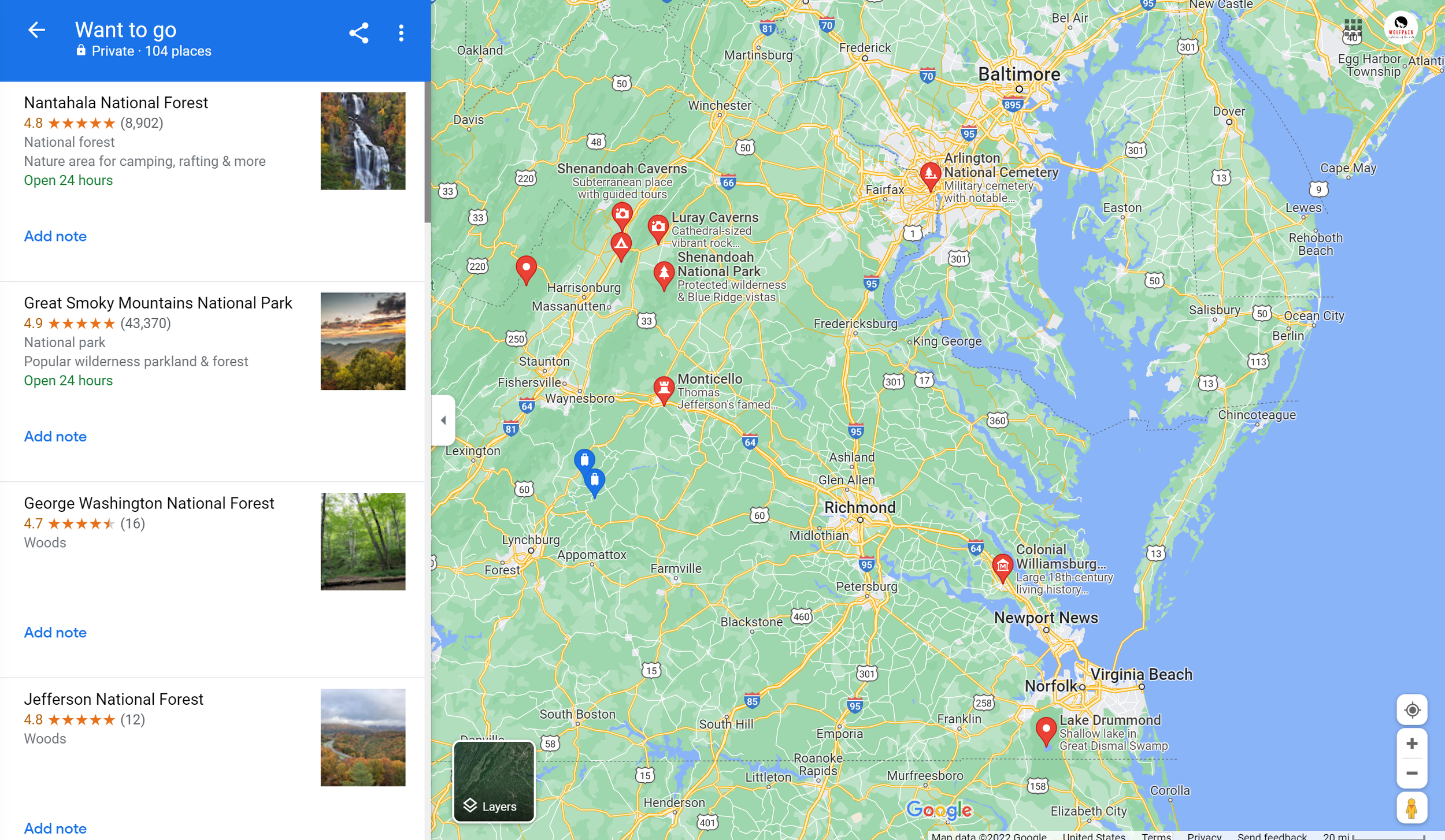
I use Evernote extensively for note-taking and research. I have created a notebook for each state and keep a list of places to visit and top campsites for that state. I will also use Evernote Web Clipper to save articles or websites for later reference. Once done, we pull up the map and see where most of the places are that we want to visit in the state. In general, a lot of the items tend to clump together as you can see in the example above. This then determines the general area where we want to stay.
From there we start investigating campsites. For this, we use a variety of tools. Of course the first place we start though is Google and search for the best campsites and RV parks near a specific city or park. There is a lot of information out there, especially on RV and state parks. But in order to get really granular, we use tools like Campendium. In Campendium you can either search for a specific city and they will show all the RV parks and campsites in the area, or you can search for a specific park. All of the info from Campedium is user-submitted, so you get an overall star rating, visitor reviews, longest RV length reported, last reported fees, if they are pet-friendly, user-submitted photos, and more. They even offer information on boondocking sites which is very helpful, especially out west.

Once we have selected a site we add it to our route. For our route planning, we use RV Trip Wizard from RV Life, it is a fantastic and powerful tool. Similar to Campendium, you can search for a city or a specific site. Once you find a site you can add it directly to your route. It even gives you the option to pick between which stays in your route you want it. Want to make a change? You can remove a current site and add a new one in it’s place.

RV Life will automatically route you to and from the site in the fastest and safest way possible. You add the details of your specific RV to the app, and it will create a route that is safe for you to take, with no low bridges, roads that allow RV and truck traffic, etc. You put in the number of nights that you plan to stay, the cost of that stay, and can even track your fuel costs. It will even tell you the number of miles and estimated driving time between sites so you can see if the driving distance is too far. This is the final variable we use in determining where to stay. Our entire trip is planned and stored in RV Trip Wizard. We see where we will be and when. They also have an app that when the time comes you use as your GPS to guide you between your stays.

Our off-road route planning is a little different. Here we are a lot more spontaneous, but our research starts the same. One of the areas we are always looking to visit in a specific state are National Forests. National Forests and Bureau of Land Management (BLM) land often offer a lot of options for off-road exploration. After Google, the first place we visit is the website for the National Forest. We are specifically looking for their Motor Vehicle Use Maps (MVUM).
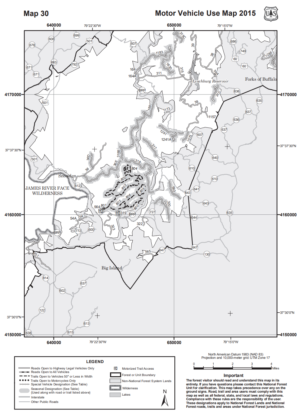
One Page from the George Washington and Jefferson National Forest MVUM
We use the MVUM to get a general idea of the number of trails available and their overall location. If it looks interesting, from there we go to our favorite off-road tool, GAIA GPS. Gaia is our main resource both for off-road trip research and planning as well as on-trail navigation and route and waypoint tracking. Before we hit the trail we look on GAIA to identify roads and areas we want to visit. We can highlight the roads that look interesting so that we can check them out if we end up being in the area. Before we leave we download the maps for the areas that we plan to visit as in most cases we will not have cell service and if we don’t download them first we won’t b able to access them.
Once in the field, we start to record our track. Recording our track allows us to see where we went once we get home and in case we need to, backtrack using the same route we came in on. We also mark waypoints for a variety of items, campsites, or potential campsites (most National Forest offer dispersed camping and allow you to camp wherever you want with only a few restrictions), wildlife sightings, checkpoints, unmarked dead ends, blocked trails, and other points of interest for future reference.

The Yellow trails are trails we highlighted in research that looked interesting. The other colors are actual tracks we have travelled.
But in general, we go where we want. If it looks interesting we check it out. We love the freedom. We have a huge database of tracks and waypoints in GAIA for Maine. While maps do exist, they are not always right. Roads go further in reality then they do in the map, or they end before the map shows. Many of the roads we travel are not even on the maps. This can be true for a lot of actively logged areas as they are creating and closing roads all the time. Want to access our GPS data and Maps for yourself? Check out our store! Currently the only maps are available are for Maine. But stay tuned, we will be adding new data as we travel. Want to go where we go or camp where we camp? Now you can!